What the Map Doesn’t Show

We have eight regions. We should have more. I want to be honest about that from the start.
The map as it stands covers London, East Anglia, the South Downs, the Thames Valley, the Cotswolds, the Heart of England, the West Country, and the Yorkshire Dales. That is a good spread. It is not a complete one. The North West is absent. The North East is absent. The Midlands proper - not the borderlands but Birmingham, the Potteries, the Black Country - is absent. Cornwall, which is its own world, is absent. The Lake District, which has some of the strongest stewardship traditions in the country, is absent.
The honest reason is capacity. Two people, three years, a fixed budget. You cannot cover everything, so you choose carefully and you are transparent about what you have not chosen. The eight regions were selected because they offered the densest concentration of subjects across all six categories within a geography we could actually reach. London and the South Downs are close to our base. The Cotswolds and Thames Valley are a day trip. East Anglia, the West Country, the Heart of England, and Yorkshire require overnight stays but not expeditions. The practical reality of fieldwork is that you have to be able to get there, stay long enough to do the work, and get back without destroying the budget on travel.
The harder question was where to draw the boundaries. Regions in England are not administrative units. They are felt territories - places that people who live there recognise as coherent but would define differently depending on which village they are standing in.
The Cotswolds and the West Country overlap. Where does the Cotswold stone end and the Somerset clay begin? Geologically, at the Jurassic scarp. Culturally, somewhere around Bath, which could belong to either or neither. We drew the line at the Mendips: north of the Mendips is Cotswolds territory, south is West Country. It is imperfect. Bath is orphaned. But you have to draw a line somewhere or the regions dissolve into each other and the architecture collapses.
London does not behave like the other regions. Every other region is defined by landscape and the traditions that grow from it. London is defined by density and institutional survival. The Livery Companies, the Inns of Court, the City churches, the market porters - these are urban traditions that exist because London has been continuously occupied for two thousand years and some of its institutions have simply never stopped. The region feels different because it is different. A Smithfield porter and a Swaledale fell farmer are both carrying something essential, but the texture of their lives could not be more remote from each other.
The regions are driven by subjects, not geography. This is important and I want to be clear about it. We did not start with a map and fill it in. We started with a list of people - the seventy-four contacts who became the subject pipeline - and worked backwards to the regions they inhabited. The map is a consequence of the people, not the other way around.
This means the map has gaps that are geographic but not intellectual. The Lake District is absent as a region but its stewardship traditions - hefted flocks, fell farming, dry stone walling - are represented through Yorkshire, which shares the same practices and in some cases the same families. The North East is absent as a region but its carrier traditions - the Northumbrian Gathering, the Durham Miners’ Gala - are acknowledged in the national essays that sit outside the regional structure. Nothing is invisible. Some things are just waiting for Phase Two.
Phase Two will add at least three regions: the North West (centred on Lancaster and the Fylde coast), the North East (centred on Northumberland and Durham), and Cornwall. Each of these has a distinct enough character and a dense enough subject pool to justify its own section. The timeline is 2028, funding permitting. If it takes longer, it takes longer. The architecture is built to expand.
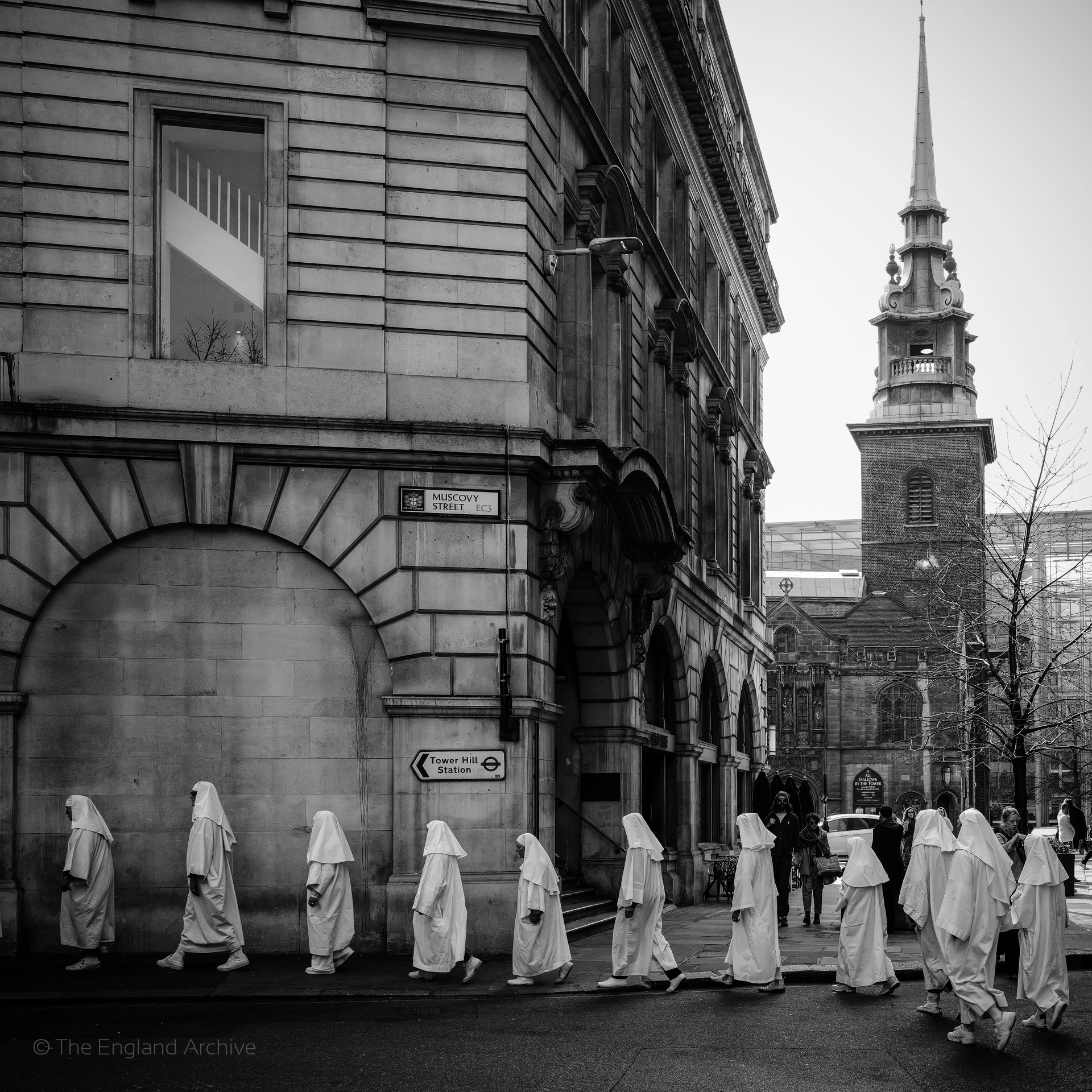
Within each region, the areas were chosen the same way - subject-first. Tower Hill is a London area because the Druid Order processes there every equinox. Smithfield is an area because the market porters are still there. The Fens are an East Anglia area because the eel catchers and the pump operators are there. Each area is a place where at least two subjects from different categories overlap, creating the kind of density that justifies a dedicated section on the site and, eventually, a dedicated fieldwork visit.
Three areas per region, except London which has four. Twenty-five areas total. It is enough to start. It is not enough to finish. The map will grow as the fieldwork reveals subjects we did not anticipate, in places we had not planned to visit. That is how documentary work actually functions - you build a structure strong enough to hold what you know, and flexible enough to accommodate what you do not know yet.
The map does not show everything. It shows where we are starting, and it shows that we know where we are not starting. That transparency matters more than completeness.